
By Paul Chappell · 11 May 2026 · Simba Sea Trips
Updated 13 May 2026 — Twenty-four hours after first publication, the synoptic picture has shifted. See the Update section at the bottom of this article for the revised outlook, plus the updated charts inline beneath each original chart.
Phuket’s southwest monsoon begins each year around mid-May, when the prevailing wind reverses from easterly to southwesterly, swell heights on the west coast rise, and afternoon thunderstorm activity intensifies. The 2026 transition is underway across the week of 11 May — with good operating conditions Monday through Wednesday, acceptable conditions on Thursday, still-variable winds on Friday, and a rise in wave heights and thunderstorm frequency from Saturday late afternoon onwards. The Sunday-to-Monday window was initially forecast at >2 metre wave heights with stronger gusting winds; the 12 May evening model runs have since softened and delayed that signal (see update below) — at this point Sun-Tue is to be monitored rather than written off.
If you’ve been on Phuket for the last week or two, you’ll have noticed the mornings have been unusually still. Light easterly breezes, glassy water at the marina, the kind of sea state we associate with the back end of the dry season. That’s about to change — and it’s worth understanding why, because the change has real, practical consequences for anyone planning to be on a boat over the next five months.
For a Phuket boat operator, this is the most important weather transition of the year. It’s also the one that’s hardest to read if you don’t know what you’re looking at. So I want to use this post to walk through what’s actually happening this week, show you the tools we use to read it, and — at the risk of being unpopular with the rest of the industry — give some honest guidance on whose weather advice you should be taking right now.
This week, day-by-day
Bottom line: good operating conditions Monday through Wednesday. Thursday acceptable. Friday still variable, not yet a settled southwesterly. Saturday: variable to suitable. Sunday-Tuesday: initially flagged for cancellations but the 12 May 18 UTC update has softened and delayed that outlook (see update section below) — monitored daily, no certainty conditions will reach cancellation thresholds.
- Monday 11 May to Wednesday 13 May — Good operating conditions. Calm seas, light easterly to variable winds, excellent visibility. Operationally indistinguishable from late dry season.
- Thursday 14 May — Still acceptable. Winds begin to vary, wave heights remain manageable, and convective activity is not yet a daily feature.
- Friday 15 May — Wind direction is still variable rather than a settled southwesterly. Wave heights and precipitation are not yet consistently larger; we expect to run tours as planned, subject to a morning-of review.
- Saturday 16 May (late afternoon onwards) — Wave heights begin to rise and heavier rain associated with thunderstorm activity becomes more frequent through the area.
- Sunday 17 May and Monday 18 May — Initially forecast as 2+ metre wave heights with stronger gusting winds. The 12 May 18 UTC analysis has softened and delayed this outlook (see Update section below) — these days are now to be monitored rather than written off, with no certainty that conditions will reach cancellation thresholds.
- Tuesday 19 May — Continues to be monitored alongside Sunday and Monday per the 12 May update.
A framing note worth being clear about: the southwest monsoon — roughly May through October — is our normal operating environment, not a danger zone. We run tours through most of it under conditions that are well within acceptable operating levels. Cancellations are triggered by specific forecast thresholds — for the days shown above, wave heights above 2 metres combined with stronger gusting winds — not by the season itself. Most days through the wet season look very different, and most of them are operating days.
What the charts are showing us
The synoptic picture this week shows the high-pressure ridge that has been sitting over mainland Southeast Asia for most of the dry season finally breaking down. As it retreats north, the pressure gradient that has been driving steady easterly flow across the Andaman weakens. By mid-week we’re forecast to see a period of light, variable winds — the calm hinge of the transition. Then a thermal low begins to dominate over the Indian subcontinent, and the gradient reorganises in the opposite direction: pulling moist, unstable air up from the equator across the Andaman Sea and into Phuket from the southwest.
This is not a forecast of disaster. It’s a textbook seasonal switch. But it has real, practical consequences for anyone planning to be on a boat this week — and over the next five months.
Why this matters for boat trips
Two things change when the wind goes southwesterly in May.
The first is sea state. A 15-knot southwesterly across Phuket and Phang Nga Bay produces a noticeably different ride from a 10-knot easterly. The fetch — the distance over open water the wind has had to build the sea — is much longer from the southwest. You feel it as a steeper, shorter chop, particularly on the west-coast passages and out toward Phi Phi. Boats that handled the easterly season effortlessly start to need a slightly slower cruise speed and more deliberate route planning.
The second, and more important, is convective activity. The southwest monsoon brings warm, moist, unstable air. In the tropics, unstable atmosphere plus a long day of solar heating equals afternoon thunderstorms. Through May and into the full monsoon season, the most statistically significant thunderstorm activity in Phang Nga Bay and across the Andaman tends to build between roughly 14:00 and 19:00 local time. This is not a Phuket-specific quirk — it is the climatological diurnal cycle of tropical maritime convection, the same afternoon peak that pilots operating across tropical Asia (Bangkok, Singapore, Hong Kong, Manila) are required to plan their day around, and a well-documented feature of every standard tropical meteorology reference.

This is the part most tourist-facing weather copy glosses over. “Wet season” gets translated into “expect a bit of rain in the afternoons”, which makes it sound like an inconvenience. It isn’t. A mature tropical cell can produce 30 to 50 knots of squall wind, blinding rain, and lightning, in a window of 20 minutes. If you’re prepared for it and you’ve planned to be back in port before the window opens, it’s a non-event. If you’re 40 minutes from the marina with the cell directly between you and home, it’s the kind of afternoon that ends up on a TripAdvisor review.
The two Phuket seasons, side by side
For visitors planning around the year, here is the comparison in one table.
| Feature | Northeast Monsoon (Nov–Apr) | Southwest Monsoon (May–Oct) |
|---|---|---|
| Dominant wind direction | Easterly to north-easterly | South-westerly to westerly |
| Typical wind speed | 5–15 knots | 15–25 knots |
| Sea state on the west coast | Generally calm, glassy mornings common | Larger swells, open Andaman fetch |
| Rainfall pattern | Mostly dry, occasional brief shower | Daily afternoon and evening thunderstorms |
| Best boat-trip timing | Flexible — full-day itineraries all day | Earlier departures, return mid-afternoon |
| Visitor season | High season | Shoulder / low season |
The transitions in April–May and October–November are the most dynamic — and the most likely to surprise visitors who arrived with one weather expectation and find themselves living in the opposite one a few days later.
The seasonal mechanics, briefly
For readers who want the bigger picture: Phuket sits inside the Asian monsoon system, which reverses twice a year. The reversal is driven by differential heating between the Asian landmass and the surrounding oceans, and by the seasonal migration of the Intertropical Convergence Zone (ITCZ). In summer, the Asian continent heats faster than the surrounding seas, creating a thermal low over the subcontinent that pulls moist equatorial air northward — the southwest monsoon. In winter, the continent cools faster, the pressure pattern reverses, and dry continental air flows offshore — the northeast monsoon. This is the same physical mechanism that governs every monsoon system on the planet; Phuket simply sits in one of the cleanest examples of it.
The tools we actually use to read it
There’s no shortage of weather apps. Some are excellent, some are theatre. Here’s what gets opened on the bridge every morning before we decide whether boats are launching.
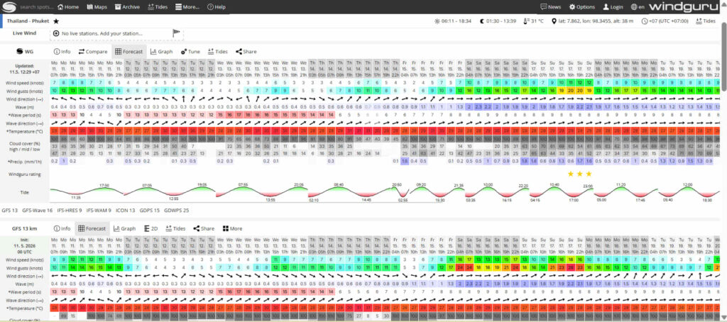
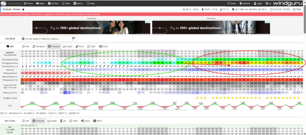
Windguru is the day-to-day workhorse. The Phuket forecast page gives you wind speed, direction, gust spread, wave height, precipitation, and cloud cover at three-hour intervals over a five-to-ten-day window, drawn from multiple model runs. The most important habit to develop with Windguru is to read the wind direction arrow first, then the speed, then the gust column. A 10-knot wind from the east is a different operational picture from a 10-knot wind from the southwest, and Windguru tells you both — but only if you’re reading the arrow, not just the number.
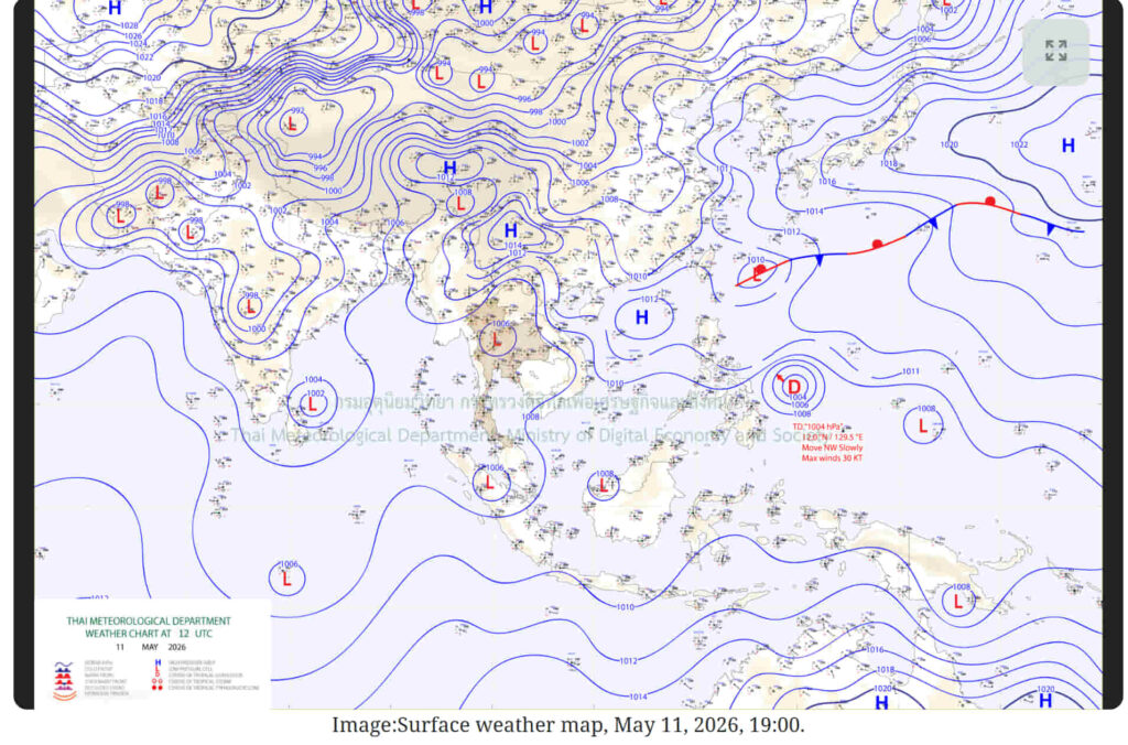
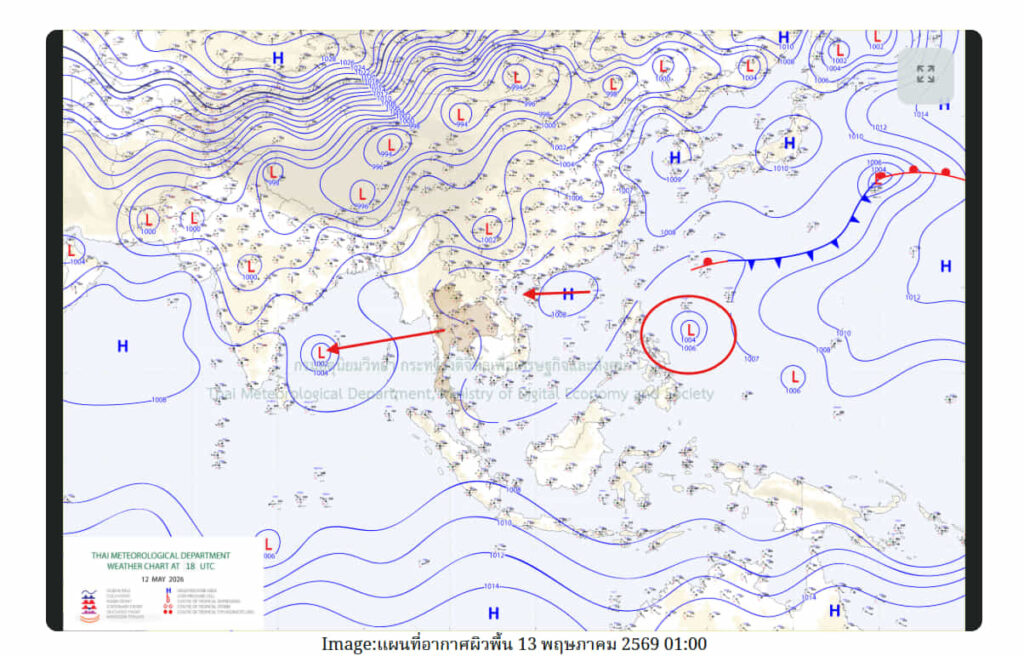
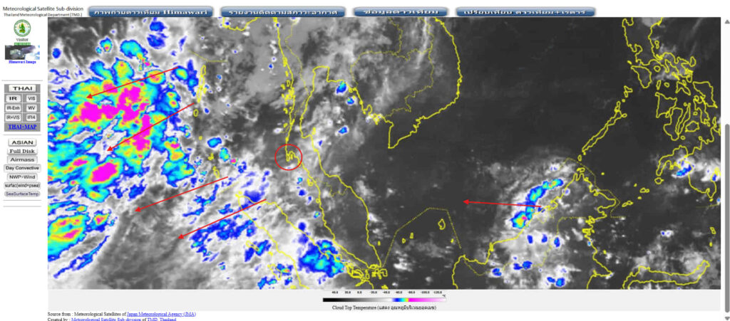
Synoptic pressure charts from the Thai Meteorological Department, the Australian Bureau of Meteorology, and the regional analyses out of JTWC (the Joint Typhoon Warning Center in Hawaii, which monitors all tropical activity in our part of the world). These give you the upstream picture — what’s coming, not just what’s here. The spacing of the isobars tells you the pressure gradient, and that tells you how strong the wind will actually be when the front arrives.
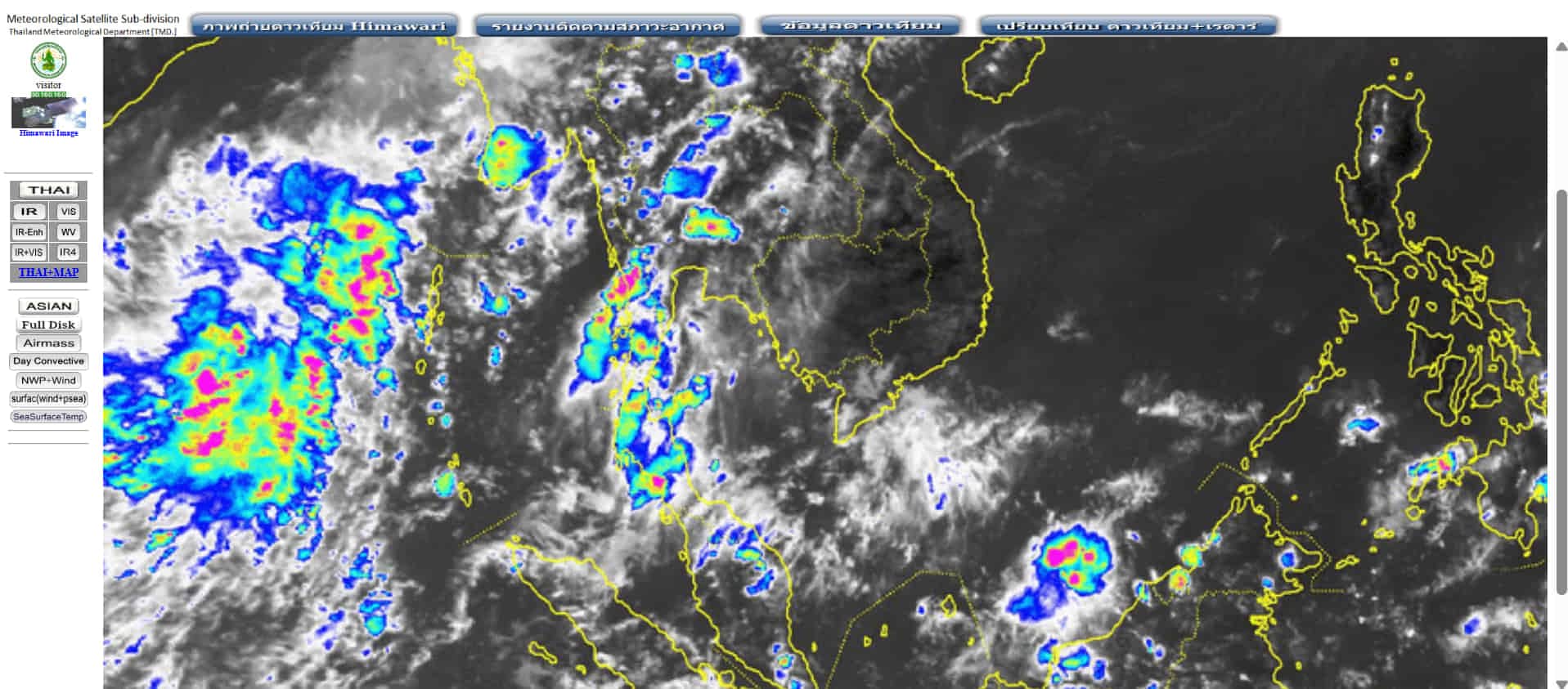
Satellite imagery, principally the visible and infrared loops from Himawari-9, the Japanese geostationary satellite that covers our region. Twenty minutes of recent satellite imagery will tell you more about what your afternoon is going to look like than any text-based forecast. You can see the convective cells forming, their direction of travel, and whether the line you’re worried about will pass north of you, south of you, or directly over the marina.
Earth Nullschool and Windy are useful for visualising the broader flow pattern — particularly helpful for seeing how the southwest monsoon establishment looks across the wider Andaman and Bay of Bengal.
One important caveat that doesn’t always get spelled out: Windguru, Windy and the rest of these visualisation tools are computer-modelled predictions, not real observations. They take outputs from numerical weather models — the same models that national meteorological agencies run — and present them at your chosen forecast point. They are most reliable inside roughly a 48-hour window. Beyond 48 hours the spread between successive model runs widens, the small atmospheric inputs that drive a convective afternoon get noisier, and the forecast becomes a useful trend indicator rather than a confident prediction. Beyond about five days, you’re effectively reading a probabilistic guess. We treat anything inside the 48-hour window as plannable; anything beyond that, we read for the broad pattern only and re-evaluate daily as the window narrows. If a tour operator is telling you with confidence what next Wednesday’s weather will be, they’re either guessing or they don’t know how the models work.
None of these tools is magic. They are model outputs, and models are wrong sometimes. What they give you is the basis for an informed judgement — provided you have the training to read them properly.
One more thing worth knowing — and this is important if you’ve arrived in Phuket and are checking the weather on your phone. The generic weather summary you’ll see on your iPhone Weather app, the Android Google Weather widget, or any other built-in mobile-device weather summary is rarely useful for marine decision-making. These apps display city-level forecasts — a single forecast point pulled from a model grid that may be 10 to 30 kilometres from where you actually plan to be on the water. “Phuket: scattered showers” can mean showers are firing inland over Patong while the marina at Boat Lagoon is in sunshine, or vice versa. For the kind of local detail that matters in marine operations, the dedicated tools above all let you read the specific forecast point you care about — the marina, the bay, the route — rather than a city-wide average that hides everything important. Don’t make a tour-or-no-tour decision based on what your phone’s lock screen tells you about “Phuket weather”. It isn’t lying — it just isn’t answering the question you’re really asking.
A friendly note on weather advice
This is the part I’d like every visitor to read carefully.
Phuket has hundreds of tour operators. Most of them are good people running honest businesses. But almost all of them have a financial interest in your boat trip running — and very few have any formal training in meteorology. When you ask “is the weather going to be fine?”, you are asking a commercial question of someone who is not qualified to answer it, and who has an incentive to say yes.
I’m not saying anyone is being deliberately misleading. Most operators genuinely believe the weather will hold, because that’s what they need it to do for their day’s revenue. But “I think it’ll be fine” is not a weather forecast. It’s a hope, dressed up with confidence.
The honest version of the conversation is: always cross-check what you’re being told against a neutral source. Windguru is free, in English, and trusted by the entire regional sailing and watersports community. The Thai Meteorological Department publishes daily marine forecasts. Windy and Earth Nullschool show the same data in visual form. Ten minutes with any of these will tell you whether the operator’s “weather will be perfect” matches what the atmosphere is actually doing.
We’d rather you did that check and felt comfortable than we’d rather you took our word for it.
And one specific caution for this time of year
If you take one operational piece of advice away from this post, please take this one.
Through the southwest monsoon transition and the full monsoon season — roughly mid-May through October — be cautious about booking boat trips that finish during the evening hours.
The afternoon-to-early-evening window, broadly 14:00 to 19:00, is statistically the most likely time for strong and intense thunderstorm activity in Phang Nga Bay and across the Andaman. As noted above, this is the diurnal cycle of tropical maritime convection — a documented climatological pattern, not a local quirk. A boat trip that finishes during the evening is, by definition, still out on the water during exactly that window. Some of those evenings will be glorious. A meaningful number will not.
At Simba we deliberately schedule our trips to be back in Boat Lagoon Marina before that window opens — our sunrise tours depart early and return mid-afternoon, our Phang Nga Bay sunset tours are monitored closely prior to departure, and we adjust departures earlier when the satellite picture or the pressure gradient looks ugly. We’d rather move the schedule forward by an hour than push a boat through a building cell. Phang Nga Bay is sheltered from the Indian Ocean large sea swells, and thunderstorm activity is our primary concern when assessing these departures.
If you are being offered a tour that finishes in the late evening through the next five months, that’s a perfectly fair question to put to whoever is selling it to you: what’s your plan when the storms start firing? The answer will tell you a great deal about whether they’re reading the same charts the rest of us are.
What we’re doing on the water this week
Here is how we are reading the next eight days from a Simba operational standpoint:
- Monday 11 May to Wednesday 13 May — Good forecasted conditions. Scheduled join-in tours and private charters running as planned. Sea state remains gentle, easterly to variable flow, visibility excellent.
- Thursday 14 May — Acceptable conditions expected. Tours running as scheduled; we’ll review departure times the morning-of based on the latest satellite and pressure-gradient picture.
- Friday 15 May — Winds still variable rather than a settled southwesterly. Wave heights and precipitation not yet consistently larger. We expect to run tours, subject to a morning-of review.
- Saturday 16 May, particularly late afternoon onwards — The day we are watching most closely this side of the weekend. Wave heights begin to rise and heavier rain associated with thunderstorm activity becomes more frequent. Itineraries reviewed boat-by-boat. We may bring departures forward or adjust routing to keep boats clear of the afternoon convective build.
- Sunday 17 May and Monday 18 May — At this stage, we anticipate cancellations across these two days. Forecast wave heights above 2 metres combined with stronger gusting winds push the conditions beyond our operating comfort threshold and approach levels we would deem unsafe for crew and customers. We’d rather cancel cleanly and give you that honest forecast now than have you arrive on Sunday expecting a tour we can’t safely run.
- Tuesday 19 May — Monitored alongside Sunday and Monday per the 12 May update; we expect to make a call on operations each morning based on the latest synoptic + satellite picture.
This isn’t the time of year to cancel your Phuket boat plans. It’s the time of year to book with an operator who is reading the weather the way it should be read, and who is willing to move the schedule when the atmosphere says move it.
Update — 12 May 2026: forecast improving
A worked example of the 48-hour caveat I noted in the "Tools we actually use" section above. Twenty-four hours after this article was first published, the synoptic picture has materially shifted. Three observations from the latest 12 May 18 UTC analysis (see the updated chart inserted beneath the original synoptic chart above) point to a more benign outlook than the early-week forecast indicated.
1. The tropical depression off the east coast of the Philippines is weakening as it tracks westward. Originally a more concerning circulation, the low is losing organisation as it moves toward Thailand from the east. A weaker system arriving means less moist tropical air being pushed into the Andaman convergence zone.
2. A high-pressure system has formed off the east coast of Vietnam and is also tracking westwards toward Thailand. That ridge will compete with the southwesterly inflow, suppressing the unstable maritime air that was forecast to drive the worst of Sunday-Monday's predicted conditions.
3. The low-pressure system in the Bay of Bengal is moving westwards — away from Thailand. That removes a key source of the deep moisture that would have fed the convective activity. With the Bay of Bengal L pulling away to our west, there is simply less fuel in the system.
Reading the latest Windguru forecast (see the updated chart inserted beneath the original Windguru chart above), you can see the forecast poor-conditions window has now been delayed by 24 to 36 hours and softened. What was modelled as "Sunday-Monday cancellations at >2 m wave heights with strong gusts" on the 11 May runs is now showing as a softer, later signal — and depending on how the Philippines depression evolves from here, it may not eventuate at all.
Where this leaves us operationally: boating conditions are now expected to be suitable through Saturday. Sunday onwards through to Tuesday is still to be monitored, but at this point there is no certainty that conditions would deteriorate to an unsafe or uncomfortable level. We will continue to watch the satellite picture and the daily pressure-gradient updates and adjust departure planning each morning.
The rest of the article's analysis remains relevant: the southwesterly trend has set in and looks likely to remain established, conditions through the wet season will generally be wetter with larger wave heights than the dry season, and the operational disciplines outlined above — afternoon-cell awareness, morning-of departure review, the 48-hour reliability window on model forecasts — apply throughout the season.
This update itself is the article's most important point in action: a forecast that looked stark 24 hours ago has materially improved on the next model run. That is exactly why we lean on the 48-hour reliability window and update our operational plans each morning rather than committing to a fixed plan four days out.
A note on credentials
This article was written by Paul Chappell — owner and operator of Simba Sea Trips, professional airline pilot of 23+ years’ standing, qualified flight instructor, and former Lead Captain on a Boeing Business Jet. Aviation meteorology is a core syllabus subject across every level of professional pilot licensing — Private Pilot, Commercial Pilot, Airline Transport Pilot — and a recurrent training requirement throughout a flying career. The charts referenced in this post — synoptic pressure, satellite imagery, Windguru model output — are the same charts professional pilots use to plan around convective weather every day. The full author profile sits below.
Have a question about a specific date this season or a tour you’re considering? Email us — we’ll pull up the charts and give you a straight answer, even if it isn’t the one that books the trip.